THE MAHOMET AQUIFER
What is an Aquifer?
Contrary to popular belief, an aquifer is not a free flowing underground river or lake. Actually, an aquifer is a body of rock or sediment that is completely saturated – water is in it and all around it. It can be made of sand, gravel, sandstone, or other rocks that can store or transmit water. What goes in an aquifer stays in an aquifer.
The water within an aquifer often begins as rain or snow melt that seeps into the ground. The amount of water that makes its way to the aquifer varies widely from place to place depending on the type of surface and underlying soils. Once underground, water will continue to be pulled downward until it reaches an impermeable layer of rock. The movement of water through rock acts as a natural filtering process, purifying the water and removing sediment. Sooner or later water will eventually leave the aquifer and need to be replenished through a process called “recharge.”
Water that flows into an aquifer may be contaminated by many things we do at or near the surface of the earth. Contaminants may reach the aquifer through natural or man-made pathway. Deliberate disposal of waste such as landfills, septic tanks, and injection wells can have an impact on the quality of an aquifer.
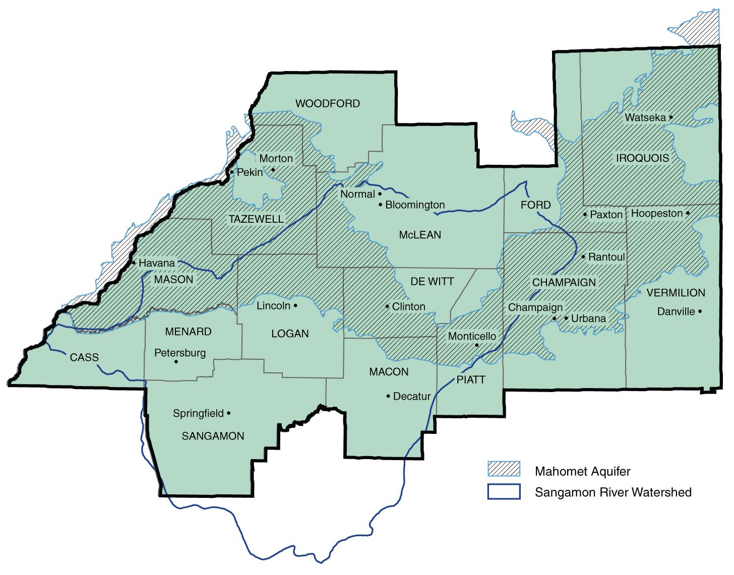
The Mahomet Aquifer
Samples of water taken from the Mahomet Aquifer are routinely dated between 1,000 and 12,000 years old; however, the geological events that lead to the creation of the aquifer were set in motion over a million years ago. The Mahomet Aquifer is composed of sand and gravel that was deposited in the valley of a river that was formed 1.5 million years ago. This ancient river was later disrupted by floods that permanently altered the landscape. The last remnants of this valley were covered by sand, silt, gravel, and clay left by advancing glaciers over 130,000 years ago.
The deposits responsible for producing the aquifers pristine waters are typically found 500 feet below the surface. These deposits average close to 100 feet thick and may be as much as 200 feet in some places. It is only in areas near the Illinois River that the aquifer reaches the surface. While many of the recharge areas – as described above – have been mapped using groundwater flow models, knowledge of these recharge areas is not complete.
MAHOMET AQUIFER ADVOCACY ALLIANCE
 What is the Mahomet Aquifer Advocacy Alliance?
The Mahomet Aquifer Coalition has reinvented itself as the Mahomet Aquifer Advocacy Alliance (MAAA), an informal association of local government and stakeholder organizations working cooperatively to safeguard the Mahomet Aquifer.
The City of Champaign was part of the Mahomet Aquifer Coalition at its conception and is proud to work with other local governments in the Mahomet Aquifer Advocacy Alliance to continue its commitment to “issue” advocacy and preserving the Mahomet Aquifer as a reliable and safe source of fresh water for our region.
MAHOMET AQUIFER PROTECTION TASK FORCE
In 2017, the Illinois General Assembly created the Mahomet Aquifer Protection Task Force (Task Force) to identify gaps in existing aquifer-protection regulations and efforts. In December 2018, the Task Force published its findings and recommendations.
Mahomet Aquifer Protection Task Force: Findings and Recommendations